Lorenz Magnum Pro HD Chart Controller
The Lorenz Magnum Pro HD chart controller is one of the most effective ways of obtaining a large screen chart plotter. The Magnum Pro HD is compatible with C-Map and Navionics charts.
The full system consists of the chart controller, a high quality monitor, Lorenz GPS antenna and a chart, all items are available separately or at an attractive package price.
- Compatible with any HDMI or DVI display
- 1 x Micro SD card slot for C-Map or Navionics chart
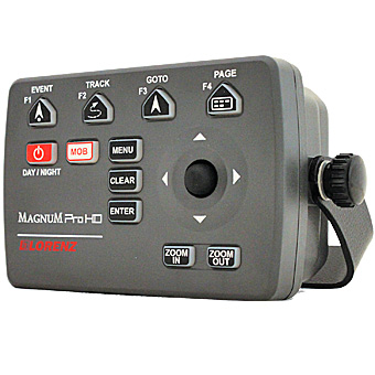
- Dedicated function keys
- AIS Compatible
- Lorenz Fishfinder compatible
- 30,000 Waypoints/Marks
- 1,000 Tracks, 30,000 points of track total
- 1,000 Routes with up to 50 points per route
- NMEA0183 & NMEA2000
- HDMI Video Output
With a large screen there is less need for scrolling and zooming, and virtually no need to change the level of detail. You can have high levels of detail for easier navigation without the screen being cluttered. The Magnum Pro HD is compatible with both C-Map Cartography and Navionics+/Platinum+.
Navionics+ Chart
SonarChart™ feature
This user selectable chart layer gives a HD bathymetry map providing additional bottom contour detail. User adjustable depth contours may be shown as low as 0.5 metre intervals. SonarChart is excellent for increasing awareness of shallow waters and for locating fish holding structure and areas at any depth level
Navionics Platinum+ Chart
Relief Shading feature
Relief Shading delivers a highly detailed layer that combines colour and shadow to provide an easy to interpret, clearer view of bottom structure - more than is possible with contour lines alone.
With the addition of colour and shading, created from the best data available such as multibeam surveys or LIDAR, Relief Shading brings bottom detail to life showing clear differences in the nature of the seabed such as rock or sand. Wreck structures are highlighted and detailed, rock ledges and reefs clear to see, all great for finding fish feeding areas.
Users may adjust the overlay opacity and so enable the visibility of hi-res contours contained in SonarCharts. Wreck icons and NavAids will also appear. Enabling this combination with Relief Shading provides the ultimate picture
SonarChart Shading is also available, it gives a unique perspective of underwater topography at a glance. Embedded within the satellite overlay layer and created from SonarChart contours, it reveals a detailed rendering of the seafloor with an easy to interpret discrimination of the depth and bottom structure in varying shades of blue
Simple and Easy to use
Simply position the cursor over the objects on the chart to get detailed information on wrecks, marinas, tidal height, buoys etc
Dedicated Function Keys
4 dedicated keys enable you to choose what functions to use at a simple touch of a button. You can program any of the following GO TO/STOP, Waypoint, Mark, Event, Track, Alarms, Route List, Mark List, Fishfinder, Page, Screen shot, Map Orientation, Map Setting and more
AIS Compatible
Enhance your safety and collision avoidance with the addition of an AIS module. View the AIS equipped vessels on your Lorenz chartplotter and view their details by simply placing the cursor on the target. Set guard zones and be alerted when an AIS target is within the guarded zone.
Lorenz Fishfinder Compatible
Turn your Magnum Pro HD into a powerful 500W or 1kW (dependent on transducer) dual frequency fishfinder by adding the Lorenz Black Box Fishfinder. View split screen chartplotter/fishfinder or whole screen chartplotter or fishfinder.
<< Back to products